Showing posts with label maryland. Show all posts

Sunday, June 9, 2024

Water is back in the canal

Top of Lock 22 (Pennyfield Lock)

In mid May I was at Great Falls along the C and O canal and noticed that the canal had been re-watered there.  I didn't know how far north they had put water back in the canal.

The canal hasn't had water in it for a few years. I actually don't remember the last time I saw it with more than a trickle of water.  The park service was replacing the locks and doing other canal maintenance all last year, I even posted about it once last year.  In 2018 and 2020 I posted about the canal at Great Falls tavern, but I think some parts of the canal to the north had water at the time.

The canal is at least mostly full between Great Falls and Lock 23 Violett's Lock. That is also the location of Inlet Lock 2, and the canal hasn't had water in it above that spot in my memory.  The water does look low, Above Swains lock it could use another foot or two of water. I'm not sure if it is still in the process of being filled or if this is the new normal.  Some spots, mostly where creeks flow into the canal are shallow enough that you can see the running water.

Islands of plants growing in the water of the canal.

Muskrat swimming in the canal

This is the first time I have ever seen a muskrat in the wild. They look alot like narrow-tailed beavers. This one totally ignored my while it swam, dove, and nibbled on grass.

 I'll also note that I drove on Canal Road on Sunday and the part of the canal near Georgetown still has no water in it.


Tuesday, May 10, 2022

Mormon Temple open house is going on now


The D.C. Mormon Temple is open for visitors from now through June 11th.  This is a rare opportunity to see the inside of a temple of the Church of Jesus Christ of Latter Day Saints.  After June 11th the temple will be rededicated and only LDS members will be allowed in.  You can find out more about how to visit at their DC Temple open house site.

This is not the first time the temple has allowed visitors.  When it was first built and prior to it's use there was an open house, but that was in 1974, so this is a a very uncommon event, it is only happening now because they just finished extensive renovations of it.

I went yesterday and it was a lot different than I expected.  I had thought it would be more like a cathedral with a huge, high-ceilinged common room, but it isn't. There are multiple floors in the temple, each largely dedicated to a different use.  The tour is self-guided but you are following a path, with plenty of knowledgable people around if you have questions (like since there is a sealing, can their be an un-sealing? [answer: yes])  You can see the tour information here and on the tour you can get a paper copy of that information.

You can't actually see every floor.  The top floor for instance is closed, but I was told that is a large gathering room with chairs and a pulpit.

You also are not allowed to take pictures inside the temple, which is why I only have exterior shots.  However, at the tour information link above there are interior pictures.


Even though I call it the "Mormon Temple" because that is what I grew up with it being known as, officially that is not it's name.  In 2018, the LDS church decided that the word "Mormon" didn't convey what they wanted.  Here is a quote from the FAQ: 

This sacred building was often called the “Mormon Temple.”  However, in 2018, the Prophet and President of the Church, Russell M. Nelson, offered correction to any inaccurate name of The Church of Jesus Christ of Latter-day Saints, including improper reference to the “Mormon Church.”  Mormon was a great prophet, whom we honor, but the Church was named after our Savior Jesus Christ. The correct name of the Church is: The Church of Jesus Christ of Latter-day Saints. Thus, the proper name of the Temple is the “Washington D.C. Temple of The Church of Jesus Christ of Latter-day Saints.” 

The reference to “saints” in the name of the Church references the Apostle Paul’s use for people who try to follow Jesus Christ’s teachings.

Friday, September 3, 2021

High water at Great Falls

 Wednesday the remnants of Hurricane Ida came through the Bethesda area and left a lot of water. I have been tracking the forecasts for the Potomac River and it was projected to peak this morning.  I went to Great Falls today to take a look, here are some comparisons for how it looks today and how it looks in slightly more normal times.

Great Falls on the Potomac River as seen from the Olmsted Island overlook.  This photo was taken in July of 2020, the water is a little bit higher than normal for mid summer.

Great Falls on the Potomac River as seen from the Olmsted Island overlook.  This photo was taken this morning. Compare it to the photo above that was taken last year,  All the rocks seen in that photo are submerged, only a few small trees on them poke above the water on the left side of the photo.


From Olmsted Island overlook looking across the Potomac River to the Virginia side.  This photo was taken in April of 2021, the water in the spring is usually higher than in the summer. On the far shore you can see the Virginia overlooks, and in the middle of the picture you can see a large tree trunk wedged between the rocks well above the waterline.

This is a photo taken this morning from almost the same spot as the prior photo. You can see the overlooks on the far shore, and, you can see the same tree trunk wedged between the rocks (and partially obscured by tree leaves. This time the river is within a few feet of it.


Friday, September 25, 2020

Hiking the Northwest Branch south of Colesville Road


 On Route 29, Colesville Road is Burnt Mills East park, it is on the same side of the road as the Trader Joe's and California Tortilla.  This park has a reasonably sized parking area and a number of nice trails.  Facing the trailheads, the trail on the right is closest to the Northwest Branch and it is called the Fall Line trail.  It Proceeds downstream and ends when it meets the Northwest Branch trail.  On the left is the Northwest Branch trail. In this area it is higher up the hill than the Northwest Branch stream, but it will eventually come down and meet the stream where the Fall Line Trail ends.  The Fall line trail is the steeper, rockier of the two trails and is only suitable for hiking, whereas the Northwest Branch trail has been designed to allow biking too.


Another trail in the area is the Copperhead Run trail.  There are 3 "chute" trails that connect it to the Northwest Branch.


The Northwest Branch itself is a good-size stream.  In many places it is rocky, but other areas are smooth and placid.


One of the interesting, but noisy, sights is where Interstate 495 crosses the stream.  The bridge is high above the trees, and although you can hear the traffic, when you are walking south it is hard to see the bridge until you are right under it.


Sunday, August 16, 2020

Go Visit: Harpers Ferry


Harpers Ferry lies at the confluence of the Potomac and Shenandoah rivers where Maryland, Virginia, and West Virginia meet. The town is in West Virginia and the lower part of the town is within the US Park Service run Harpers Ferry National Historic Park. 


You have probably heard of Harpers Ferry when you learned history in school.  It is the site of the abolitionist John Brown's raid on the US arsenal there. Brown attacked and captured several buildings; hoping to secure the weapons depot and arm the slaves, starting a revolt across the South. The raid ultimately failed when the US army sent an expedition commanded by Lieutenant Colonel Robert E. Lee (who would later become a general in the Confederate army) stormed the fire house where Brown and his men had taken refuge.

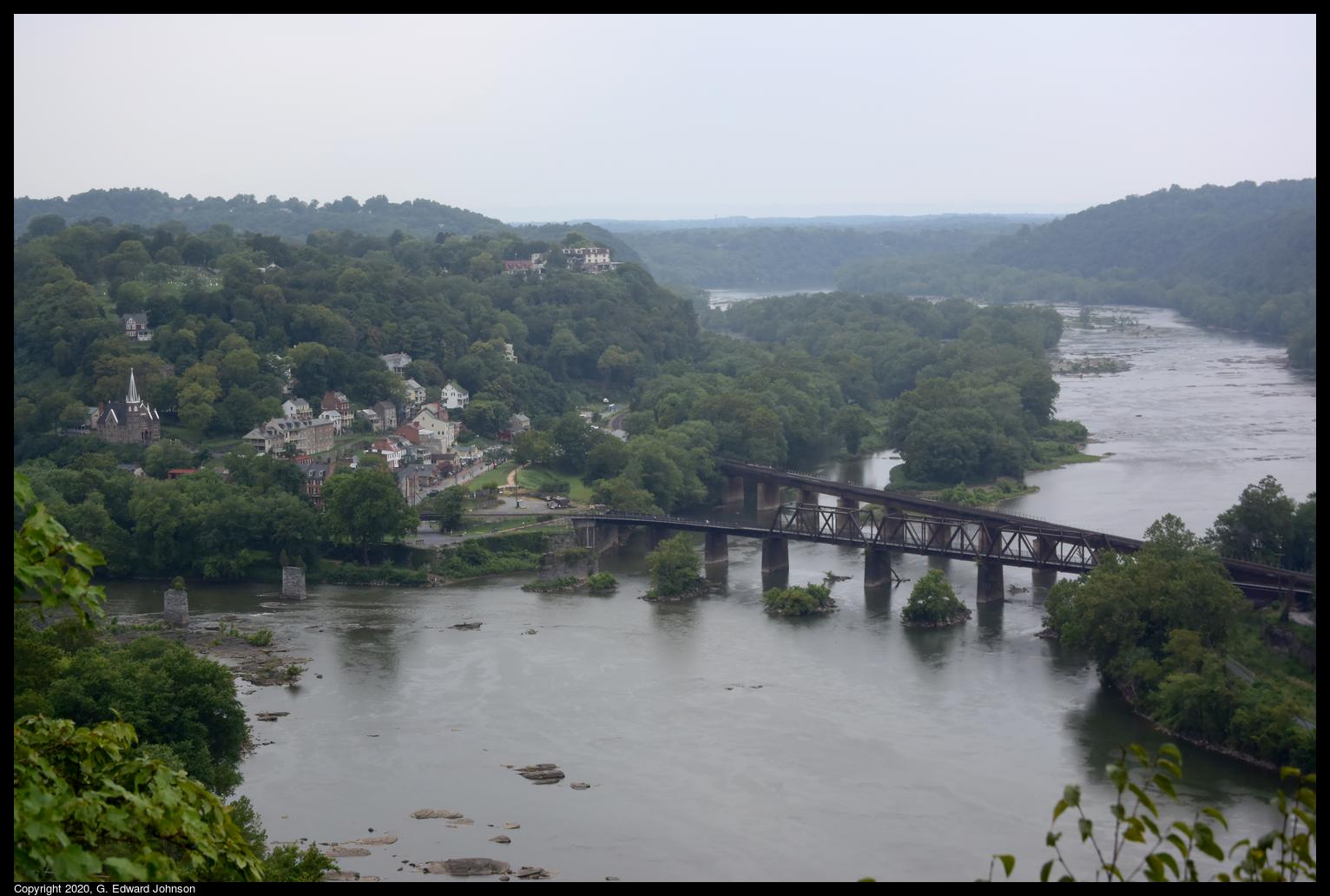
In addition to the downtown area, there are a number of hiking trails and beautiul sights to see.  There are two railroad bridges that cross the Potomac here as well as the piers of a couple of older bridges.  This one was built in 1894 and carries the CSX Shenandoah Subdivision line toward Winchester Virginia. The other bridge is just upstream was built in 1930 and caries the CSX Cumberland Subdivision line to Martinsburg, WV.

The bridge also carries the Appalachian Trail across the Potomac River.  This crossing was closed in late 2019 because of a train derailment, but the damage was fixed and the trail reopened in early July of this year.

A popular hike is to start in downtowm Harpers Ferry, cross the Potomac on the Appalachian Trail, travel north on the C & O canal a short distance, then take the Maryland Heights trail up to an overlook with a stunning view of Harpers Ferry and the rivers.

Here's the view of Harpers Ferry, the two railroad bridges, and the confluence of the Shenendoah River (top) and the Potomac River (bottom).  You can see piers from older bridges crossing the Potomac just to the left of the railroad bridges, and piers from a bridge that crossed the Shenandoah just before the confluence.


The C & O canal also runs along the Maryland side of the Potomac River.  The canal doesn't have water in it but the tow path is well maintained and is a popular place for hiking and biking. Here we are looking down at the bright ribbon of the C & O canal towpath and the Potomac River.  As seen from Maryland Heights, a large rock outcropping that overlooks Harpers Ferry, WV.

 Another hike you can do is to cross the Shenandoah River on the US Route 340 bridge (which is also used by the Appalachian Trail, so there is a separated walkway), follow the trail up the mountain then take a left on the Loudoun Heights overlook trail.  This takes you to an overlook where you can see Harpers Ferry from just below the confluence of the Shenandoah and Potomac rivers.


Wednesday, August 12, 2020

Go Visit: Seneca Creek Greenway Trail at River Road

 Last month, I explored the Seneca Creek Greenway Trail starting at Maryland Route 28 and going west towards the Potomac River.  Today I'm starting at the western end of the trail and going east, towards MD-28.

If you are a purist, you will want to start at the official beginning, at the ruins of Seneca Mill, or at Riley's Lock, where Seneca Creek flows in to the Potomac river.  In either case, the first mile is walking along a road.  Since I'm not a purist, and I don't enjoy walking along the side of roads, I started just across River Road, on Seneca Rd.  There is a wide shoulder there with enough parking for 3-4 cars.

This trail goes through varied terrain, sometimes heavily wooded, sometimes meadows, and everything in between.

If you aren't familiar with the Seneca Creek Greenway trail, it runs all the way from the Potomac River to Watkins Mill Road, a total of 24 miles.  North of Watkins Mill, it continues as the Lower Magruder Trail.


The first 1.3 miles connects Seneca Road to Berryville Road.  It is a hilly section of the trail with lots of ups and downs.  The trail is forested and shady.  There are a couple of small streams with wooden bridges over them.

Along the way I saw this old log with a mass of miniature mushrooms growing out of it. I was surprised both at how many there were and how small they are.  Other parts of the trail in this area have ferns growing right up to the trail's edge.

Towards the end, it can get confusing, what looks like a path that leads off to the left with access to the creek is really the main trail.  Go down the hill and cross the creek on stones.  If you get to a road (Berryville Rd), you've gone too far, but don't panic, just take a left and walk along the road until you see a parking area and the trail again.

At the parking area, the trail continues on, 4.4 miles to MD Route 28. This post won't cover the whole way, just to the Berryville Road Side Trail.


Seneca Creek is deep and wide here. Lots of families come to splash in the water and swim.  Shortly after this area the trail veers away from the creek and you won't see much of it again, so enjoy the water now.  From here on the trail is mostly flat with the occasional hill.

The trail has mile posts every half mile so you can keep track of your progress, it also has these blue posts with the trail name on it.  Even with that, it isn't all that well marked.  There are lots of side trails and it sometimes isn't clear which trail is the main trail. It would be nice if they had signs where trails met so you know which way to go.

There are a couple of places where you can see signs of the past.  Here is a couple of long refrigerator cases. I'm not sure how they got here, and they have obviously been here for a while, but out in the middle of the woods, just a little way off the main trail is this old refrigerator case from a grocery store.

A stretch of the trail goes through a meadow.  Here is near the start, as the trees give way to grass.

Another sign of the past.  In some places you can see remnants of fence from before this area was a park. Here, right by the path, are several strands of barbed wire coming out of a tree.

The trail crosses a number of small streams, many of them have bridges built over them.

One of the few marked side trails is this one, the sign says Berryville Road side trail, and it should take you back to Berryville Rd.  This is where I turned around.  If you want to see what there is if you continued, read my post on the trail starting at MD-28.  You can also learn more about Seneca Creek on Wikipedia.

Sunday, August 9, 2020

It's not too late to go see the sunflowers

 Sunflower season is drawing to a close, but it isn't too late to go see the fields of sunflowers at McKee-Beshers wildlife management area.  I went there today, and even though many of the flowers are drooping, there are still a lot that are looking up and following the sun.  Next weekend is probably the last chance to go this year.

Every year the state of Maryland plants these sunflowers to food for mourning doves and other songbirds, pollinators and mammals.  These fields are open to the public and many people go there and enjoy them each year.

 I went today and the parking areas were crowded, but the fields themselves are large so everyone spreads out when the get there.  There are several parking areas and the fields are a short walk on level ground away.


Directions:
From the Capital Beltway, take Exit 39 (River Road) west toward Potomac. Proceed for approximately 11 miles to the intersection of River Road and MD 112, Seneca Road. Turn left and continue on River Road for about 2 1/2 miles. McKee-Beshers will be on your left as you head west on River Road.


Saturday, August 1, 2020

Kayakers at Great Falls

I often see people kayaking when I go to great falls.  Usually they are in the whitewater below the falls, but sometimes they go above the falls and come down on the Virginia side of the river.  Today I saw something different though.  I saw a group of 3 kayakers come down the biggest drop, along the Maryland shore. You can see the first kayak coming over the falls in the photo above

Take a look at this video I took.  About 8 seconds in the first kayak comes over the falls, then another, then another.  They regroup in the calmer water below then continue down and shoot through some intense white water at about 1 minute 20 seconds.


Thursday, July 16, 2020

Go Visit: Seneca Creek Greenway Trail at MD-28


The Seneca Creek Greenway trail runs for 16.2 miles alongside Seneca Creek in Montgomery County, MD.  There are a number of places to access this trail and I went to the one on MD-28, Darnestown Rd.  I walked west, towards the Potomac River, which is a bit over 6 miles away.

The entrance to the parking lot is easy to miss. As you are going west on 28, it is on the right, just before the bridge over Seneca Creek.  It is a gravel parking lot that will fill up on weekends, but even when it is full, there aren't many people on the trail.  At the far end of the lot is an information sign and the entrance to the Seneca Creek Greenway trail towards the Potomac River.  At the other end of the lot is the trail going towards Black Rock Mill.

After a quick walk down a gravel path, then a little bit of old MD-28, the trail goes off to the left, under the bridge.

There are a number of places you can access the creek from the Seneca Creek Greenway trail.  Here there is a wide gravel bank alongside the water.

The trail is mostly flat, not a lot of hills so it is an easy and relaxing walk.  There are blue trail marker that say "Seneca Greenway Trail" so you don't need to worry about getting lost. The trail is natural surface and goes through a mix of grassy areas, older trees, and some young trees.

Wednesday, July 1, 2020

Go Visit: Whites Ferry

 There is still an operating ferry in the DC area.  Whites Ferry crosses the Potomac near Poolesville in Maryland and Leeseburg in Virginia.  You can take your car across it.  You pay when you get on the barge, no need to pay in advance.  If you have never been on a ferry, it is a fun trip.  I used to commute from Maryland to Dulles, VA and would take the trip twice a day, it was much more enjoyable than being stuck in traffic on the American Legion Bridge.

 Here is the store and grill attached to the ferry, I'm not sure if it is open right now due to CoViD-19

Whites Ferry is also a great place to start a walk or bike ride along the C and O canal.  The canal doesn't have water in this area, but the tow path is in good condition and made of compacted crushed stone dust.  The canal runs all the way from Georgetown in Washington DC to Cumberland, MD.  A total of 186 miles.

Here is the remains of a tunnel that took a creek under the canal, and behind it, a bridge that used to take vehicles over the canal to the ferry.

 Looking south down the canal.  On the right is the tow path, on the left, between the trees is river road.

River Road goes all the way to Whites Ferry, It is a narrow gravel road by the end.

Tuesday, April 7, 2020

Outdoors and excercising with distance

For the past three weeks I've been working from home and exercising by walking around the neighborhood.  This past weekend I really wanted to go for a long walk and have a change of scenery.  Mid March I went to Great Falls (which was great, btw) but the towpath between Great Falls Tavern and the Billy Goat Trail was pretty crowded and I wanted to go somewhere it was easier to maintain my social distance.

I went further north up the canal to get away from the crowds.  I skipped Swain's Lock because it is close enough to Great Falls it gets some of that traffic and it has a small parking area.  There are several other spots that are just a short distance further, the one I chose was Rileys Lock which is conveniently on Rileys Lock Road.  This is where Seneca Creek joins the Potomac River.


There were other people there, walking, running, and hiking but they were easy enough to keep a distance from.  You can see from these first two pictures that much of the time there was no one in sight.

If you choose to bike there, be warned, the tow path isn't as smooth after Riley's lock as it is before and there are muddy areas.  Since it hasn't rained hard in a while they were generally easy to avoid, but in past years when I've gone it has occasionally been treacherous.

Here's a father that will let nothing get in a way.  He was riding on a bicycle built for two with his pre-teen child helping pedal.  Behind that were two more kids in a double trailer (one behind the other) and behind that was another trailer with 3 bikes in it.  I can only imagine the amount of energy pedaling that took.