Sunday, August 16, 2020

Go Visit: Harpers Ferry


Harpers Ferry lies at the confluence of the Potomac and Shenandoah rivers where Maryland, Virginia, and West Virginia meet. The town is in West Virginia and the lower part of the town is within the US Park Service run Harpers Ferry National Historic Park. 


You have probably heard of Harpers Ferry when you learned history in school.  It is the site of the abolitionist John Brown's raid on the US arsenal there. Brown attacked and captured several buildings; hoping to secure the weapons depot and arm the slaves, starting a revolt across the South. The raid ultimately failed when the US army sent an expedition commanded by Lieutenant Colonel Robert E. Lee (who would later become a general in the Confederate army) stormed the fire house where Brown and his men had taken refuge.

In addition to the downtown area, there are a number of hiking trails and beautiul sights to see.  There are two railroad bridges that cross the Potomac here as well as the piers of a couple of older bridges.  This one was built in 1894 and carries the CSX Shenandoah Subdivision line toward Winchester Virginia. The other bridge is just upstream was built in 1930 and caries the CSX Cumberland Subdivision line to Martinsburg, WV.

The bridge also carries the Appalachian Trail across the Potomac River.  This crossing was closed in late 2019 because of a train derailment, but the damage was fixed and the trail reopened in early July of this year.

A popular hike is to start in downtowm Harpers Ferry, cross the Potomac on the Appalachian Trail, travel north on the C & O canal a short distance, then take the Maryland Heights trail up to an overlook with a stunning view of Harpers Ferry and the rivers.

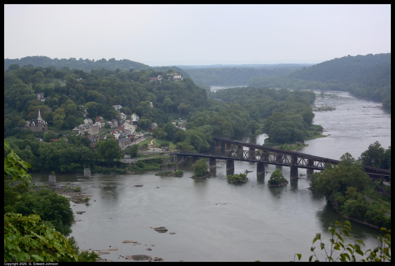
Here's the view of Harpers Ferry, the two railroad bridges, and the confluence of the Shenendoah River (top) and the Potomac River (bottom).  You can see piers from older bridges crossing the Potomac just to the left of the railroad bridges, and piers from a bridge that crossed the Shenandoah just before the confluence.


The C & O canal also runs along the Maryland side of the Potomac River.  The canal doesn't have water in it but the tow path is well maintained and is a popular place for hiking and biking. Here we are looking down at the bright ribbon of the C & O canal towpath and the Potomac River.  As seen from Maryland Heights, a large rock outcropping that overlooks Harpers Ferry, WV.

 Another hike you can do is to cross the Shenandoah River on the US Route 340 bridge (which is also used by the Appalachian Trail, so there is a separated walkway), follow the trail up the mountain then take a left on the Loudoun Heights overlook trail.  This takes you to an overlook where you can see Harpers Ferry from just below the confluence of the Shenandoah and Potomac rivers.


Wednesday, August 12, 2020

Go Visit: Seneca Creek Greenway Trail at River Road

 Last month, I explored the Seneca Creek Greenway Trail starting at Maryland Route 28 and going west towards the Potomac River.  Today I'm starting at the western end of the trail and going east, towards MD-28.

If you are a purist, you will want to start at the official beginning, at the ruins of Seneca Mill, or at Riley's Lock, where Seneca Creek flows in to the Potomac river.  In either case, the first mile is walking along a road.  Since I'm not a purist, and I don't enjoy walking along the side of roads, I started just across River Road, on Seneca Rd.  There is a wide shoulder there with enough parking for 3-4 cars.

This trail goes through varied terrain, sometimes heavily wooded, sometimes meadows, and everything in between.

If you aren't familiar with the Seneca Creek Greenway trail, it runs all the way from the Potomac River to Watkins Mill Road, a total of 24 miles.  North of Watkins Mill, it continues as the Lower Magruder Trail.


The first 1.3 miles connects Seneca Road to Berryville Road.  It is a hilly section of the trail with lots of ups and downs.  The trail is forested and shady.  There are a couple of small streams with wooden bridges over them.

Along the way I saw this old log with a mass of miniature mushrooms growing out of it. I was surprised both at how many there were and how small they are.  Other parts of the trail in this area have ferns growing right up to the trail's edge.

Towards the end, it can get confusing, what looks like a path that leads off to the left with access to the creek is really the main trail.  Go down the hill and cross the creek on stones.  If you get to a road (Berryville Rd), you've gone too far, but don't panic, just take a left and walk along the road until you see a parking area and the trail again.

At the parking area, the trail continues on, 4.4 miles to MD Route 28. This post won't cover the whole way, just to the Berryville Road Side Trail.


Seneca Creek is deep and wide here. Lots of families come to splash in the water and swim.  Shortly after this area the trail veers away from the creek and you won't see much of it again, so enjoy the water now.  From here on the trail is mostly flat with the occasional hill.

The trail has mile posts every half mile so you can keep track of your progress, it also has these blue posts with the trail name on it.  Even with that, it isn't all that well marked.  There are lots of side trails and it sometimes isn't clear which trail is the main trail. It would be nice if they had signs where trails met so you know which way to go.

There are a couple of places where you can see signs of the past.  Here is a couple of long refrigerator cases. I'm not sure how they got here, and they have obviously been here for a while, but out in the middle of the woods, just a little way off the main trail is this old refrigerator case from a grocery store.

A stretch of the trail goes through a meadow.  Here is near the start, as the trees give way to grass.

Another sign of the past.  In some places you can see remnants of fence from before this area was a park. Here, right by the path, are several strands of barbed wire coming out of a tree.

The trail crosses a number of small streams, many of them have bridges built over them.

One of the few marked side trails is this one, the sign says Berryville Road side trail, and it should take you back to Berryville Rd.  This is where I turned around.  If you want to see what there is if you continued, read my post on the trail starting at MD-28.  You can also learn more about Seneca Creek on Wikipedia.

Sunday, August 9, 2020

It's not too late to go see the sunflowers

 Sunflower season is drawing to a close, but it isn't too late to go see the fields of sunflowers at McKee-Beshers wildlife management area.  I went there today, and even though many of the flowers are drooping, there are still a lot that are looking up and following the sun.  Next weekend is probably the last chance to go this year.

Every year the state of Maryland plants these sunflowers to food for mourning doves and other songbirds, pollinators and mammals.  These fields are open to the public and many people go there and enjoy them each year.

 I went today and the parking areas were crowded, but the fields themselves are large so everyone spreads out when the get there.  There are several parking areas and the fields are a short walk on level ground away.


Directions:
From the Capital Beltway, take Exit 39 (River Road) west toward Potomac. Proceed for approximately 11 miles to the intersection of River Road and MD 112, Seneca Road. Turn left and continue on River Road for about 2 1/2 miles. McKee-Beshers will be on your left as you head west on River Road.


Saturday, August 1, 2020

Kayakers at Great Falls

I often see people kayaking when I go to great falls.  Usually they are in the whitewater below the falls, but sometimes they go above the falls and come down on the Virginia side of the river.  Today I saw something different though.  I saw a group of 3 kayakers come down the biggest drop, along the Maryland shore. You can see the first kayak coming over the falls in the photo above

Take a look at this video I took.  About 8 seconds in the first kayak comes over the falls, then another, then another.  They regroup in the calmer water below then continue down and shoot through some intense white water at about 1 minute 20 seconds.