Showing posts with label history. Show all posts

Monday, July 20, 2026

Foundry Branch Trestle Bridge


The Foundry Branch Trestle is how the Washington and Great Falls Electric Railway Company crossed Foundry Branch stream on it's way from Georgetown to Glen Echo.  It was built in 1896 and streetcars used the trestle until 1960. Since then it has stood alone in the woods, easily visible from Canal Road near Georgetown University.

The trees have grown up around  the Pratt truss bridge and vines work their way in from both sides, but you can still see most of it.


End of the trestle
WMATA (Metrobus/Metrorail) now owns the trestle and a determined it was unsafe. In 2016 the area was fenced off so you couldn't go under the trestle. Prior to that, the Glover-Archbold Trail ran under it.  Since then, WMATA has been trying to get permission to demolish it.

 Even though you can't walk right up to it (unless you crawl through a hole in the fence, which I did not do and don't recomend you do), you can get some pretty good views of it.  You can walk up a hill and see it from the top, if you are careful to avoid the plentiful poison ivy. Here's a view looking over one of the fences at the eastern end of the bridge.

Like a tree needs a bicycle
This is actually my favorite part. At the top of the east end of the trestle someone put a bike in the fork of a tree.  Over the years, the tree has swallowed the bike and only the seat and back of the frame can be seen, the rest is embedded in the tree.

Just last week, approval was given to demolish the Foundry Branch Trestle Bridge, the concrete trestle footers will remain, but the rest of it will be destroyed.


Tunnel under the canal
There are a few ways to get to the bridge which is right where Foxhall Road joins Canal Road. You can hike south on the Glover-Archbold trail, you could park in the neighborhoods nearby and walk down Foxhall Rd, or, what I think is the best way: you can access it from the C and O canal or Capital Crescent Trail.  There is a pedestrian underpass that goes under the canal and Canal Road, taking you right there.


Sunday, August 16, 2020

Go Visit: Harpers Ferry


Harpers Ferry lies at the confluence of the Potomac and Shenandoah rivers where Maryland, Virginia, and West Virginia meet. The town is in West Virginia and the lower part of the town is within the US Park Service run Harpers Ferry National Historic Park. 


You have probably heard of Harpers Ferry when you learned history in school.  It is the site of the abolitionist John Brown's raid on the US arsenal there. Brown attacked and captured several buildings; hoping to secure the weapons depot and arm the slaves, starting a revolt across the South. The raid ultimately failed when the US army sent an expedition commanded by Lieutenant Colonel Robert E. Lee (who would later become a general in the Confederate army) stormed the fire house where Brown and his men had taken refuge.

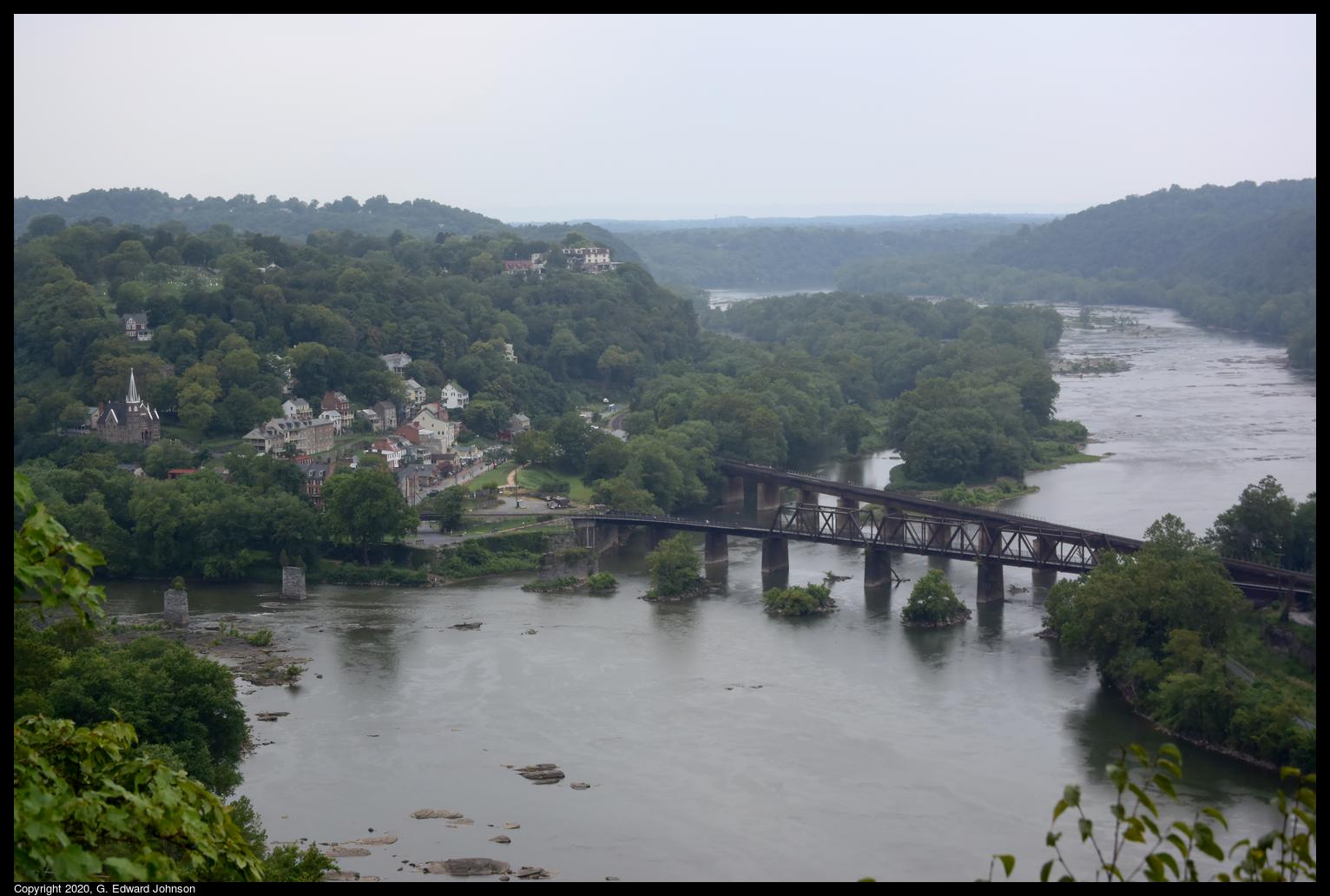
In addition to the downtown area, there are a number of hiking trails and beautiul sights to see.  There are two railroad bridges that cross the Potomac here as well as the piers of a couple of older bridges.  This one was built in 1894 and carries the CSX Shenandoah Subdivision line toward Winchester Virginia. The other bridge is just upstream was built in 1930 and caries the CSX Cumberland Subdivision line to Martinsburg, WV.

The bridge also carries the Appalachian Trail across the Potomac River.  This crossing was closed in late 2019 because of a train derailment, but the damage was fixed and the trail reopened in early July of this year.

A popular hike is to start in downtowm Harpers Ferry, cross the Potomac on the Appalachian Trail, travel north on the C & O canal a short distance, then take the Maryland Heights trail up to an overlook with a stunning view of Harpers Ferry and the rivers.

Here's the view of Harpers Ferry, the two railroad bridges, and the confluence of the Shenendoah River (top) and the Potomac River (bottom).  You can see piers from older bridges crossing the Potomac just to the left of the railroad bridges, and piers from a bridge that crossed the Shenandoah just before the confluence.


The C & O canal also runs along the Maryland side of the Potomac River.  The canal doesn't have water in it but the tow path is well maintained and is a popular place for hiking and biking. Here we are looking down at the bright ribbon of the C & O canal towpath and the Potomac River.  As seen from Maryland Heights, a large rock outcropping that overlooks Harpers Ferry, WV.

 Another hike you can do is to cross the Shenandoah River on the US Route 340 bridge (which is also used by the Appalachian Trail, so there is a separated walkway), follow the trail up the mountain then take a left on the Loudoun Heights overlook trail.  This takes you to an overlook where you can see Harpers Ferry from just below the confluence of the Shenandoah and Potomac rivers.


Wednesday, July 1, 2020

Go Visit: Whites Ferry

 There is still an operating ferry in the DC area.  Whites Ferry crosses the Potomac near Poolesville in Maryland and Leeseburg in Virginia.  You can take your car across it.  You pay when you get on the barge, no need to pay in advance.  If you have never been on a ferry, it is a fun trip.  I used to commute from Maryland to Dulles, VA and would take the trip twice a day, it was much more enjoyable than being stuck in traffic on the American Legion Bridge.

 Here is the store and grill attached to the ferry, I'm not sure if it is open right now due to CoViD-19

Whites Ferry is also a great place to start a walk or bike ride along the C and O canal.  The canal doesn't have water in this area, but the tow path is in good condition and made of compacted crushed stone dust.  The canal runs all the way from Georgetown in Washington DC to Cumberland, MD.  A total of 186 miles.

Here is the remains of a tunnel that took a creek under the canal, and behind it, a bridge that used to take vehicles over the canal to the ferry.

 Looking south down the canal.  On the right is the tow path, on the left, between the trees is river road.

River Road goes all the way to Whites Ferry, It is a narrow gravel road by the end.

Friday, November 10, 2017

Hike on the Seneca Creek Greenway trail

The Seneca Creek Greenway Trail is 7.8-mile natural surface trail.  The trail is part of a planned 25 mile greenway connection between the Potomac and Patuxent Rivers.  I went for a hike on one of the more popular sections, between MD-355 and Watkins Mill Road.

If you are going North on MD-355, at the northern edge of Gaithersburg, the road crosses a bridge over Seneca Creek.  Just after that is a gravel parking lot and a trail head.

The trail between 355 and Watkins Mill Rd is about 3 miles, so about 6 miles round trip (according to the sign at the start of the trail, it is 2.9 miles).  The trail doesn't follow the creek exactly, it is up on the side of a hill at the edge of the stream valley.

Many years ago I would go on this trail very frequently, and it used to be right on the edge of Seneca Creek for the first mile or two.  They have relocated the trail further away from the creek.

I just took these pictures on November 10th, and you can see it is late fall and most of the leaves have fallen.  There is still the occasional tree with green or yellow leaves and they really stand out against the other bare trees.

This isn't Seneca Creek, it is a very small stream that flows into Seneca creek.  You can see the bridge where the trail crosses it.  The trail is well maintained, and all stream crossings have bridges (or in one case, a huge rock).  It can get muddy and the fallen leaves can be slippery when wet, so you do have to pay attention.

This area hasn't always been a park, and there is one spot where several cars were left to rust decades ago.  There isn't a whole lot left of them now, but it is neat to see them out in the middle of the forest.


Sunday, March 13, 2016

More rail road remanants

 A couple of years ago I posted about some interesting un-identified track equipment along the Capital Cresent Trail that seems to have been part of a rail road car.  I was walking through the same area the other day and noticed that just on the other side of the trail down the embankment is what appears to be the rest of the railroad car.

  Here is one side of it, you can see the coupling where it would connect to the next car.  There are plants growing in the bed of the car and the whole area is completely overgrown, which is why I haven't noticed it before.  In another month or two this probably won't be visible from the trail (until next winter anyway).

 This is the back half of the above car.  Since there is no coupling and now sidewall, I surmise that there is only one railroad car that was intentionally cut in half and left behind.

this is the other part of the car, again you can see the coupling for connecting it to the rest of the train. The Capital Crescent Trail is at the top of the hill to the right.

The bed of the car was made of wood planks.  many of them have rotted away, especially in this area.

The Capital Crescent Trail runs along what was the Georgetown Branch rail road line, there are many small reminders of this that you can find if you look hard enough.  I have written about many of them.

Saturday, June 21, 2014

Railroad siding at Connecticut Avenue

 I like looking around for traces of the old Georgetown Branch railroad line, so I was thrilled to find another abandoned siding.  This one is on the Georgetown Branch Trail, between Bethesda and Connecticut Avenue,  In fact, it is within sight of Connecticut Ave.  In the picture above you can see the fence that marks the edge of Columbia Country Club.  There is a little path next to it and you can walk in a bit and see the rail road tracks
Abandoned railroad siding near Columbia Country Club

 The siding continues to the trees almost to Connecticut Avenue.  Here is a nother bit of it.  In the background you can see a bench and the Georgetown Branch trail.  If you zoom in you can see one of the rails is covered with a bit of chain link fence.
 The siding goes right up to the parking lot of Parkway drycleaning.  I wonder how many people have parked here never knowing what is right next to them.
End of the line
The railroad siding unceremoniously ends with the rail sticking up a bit from the ground.

Next time you are going down that part of the trail, it is worth taking a minute to check out this relic of slightly earlier times.

Sunday, June 1, 2014

Railroad siding near River Road

I have walked along the Capital Crescent Trail near River Road many times but I have never noticed the bit of railroad siding that remains in one spot.

See it? It is easy to miss, on the left about 5 feet above the trail and overgrown with vines.

Here's another closer look. This is the end of the siding, I believe this particular bit is to keep railroad cars from rolling off the end. Given how overgrown the rest is I wonder if someone pulled some vines away to make it more visible.

 I walked up the embankment to get a closer look and the rails are still there, going off to the right through the trees.  I removed some vines from a bit of the rail so I could get a better picture.  The cross ties are rotted and spongy, I thought the were going to break when I stepped on them.

The siding connected to the main line right around where the bridge that goes over River Road is.  There is a gravel road next to the trail and you can see a single rail embedded in the road.  Behind that is an open area that slopes up.  This was recently re-graded, the siding is a bit to the left and several feet lower than the current grade.


I walked back among the trees looking for more signs of the siding.  It is all still there, just overgrown with ivy and very hard to see.


Monday, April 21, 2014

Unidentified railroad track equipment


I was walking along the Capital Crescent Trail, which runs along what was once the Georgetown Branch of the B & O railroad.  There are very few remaining relics of the railroad, mostly just a partially visible rail here and there.  However, I did run across this very large, and very puzzling metal thing.


I can't really find the words to adequately describe it, so I can't really search the web to find out what it is. It is about as wide as the rails of the railroad track, has what looks like a pressurized vessel with various pipes going here and there.


If you want to see it for yourself, it is just a bit north of the Dalecarlia tunnel.  I'd like to know what it is, so if you have ideas, leave a comment.


View Larger Map


UPDATE 5/2: I heard from Ben Sullivan who runs a website about the Georgtown Branch railroad line. He said in part "It is indeed the frame of a railroad car and the piping and tanks you described on your blog are components of the brake rigging on the car." And gave a bit about a possible reason: "My best bet so far is that it's part of a derailment wreck and the useful parts of the cars (ie. the wheels, trucks, coupler boxes and bolsters where the trucks were mounted) were all cut off with a torch and taken back to the shop. The rest of the scrap was left to rot. As far as a time/date/reason as to why they were there will be much more difficult. I'm still working on this problem but I doubt I will find specifics."

Sunday, April 13, 2014

RIP White Flint Mall


Last weekend I went to White Flint Mall to see what was left.  The Boomingdales part was torn down last year and the rest of the mall has rapidly emptied out.  The only stores I saw were the post office (which closed last Friday), a jewellery store, the Dave & Busters (which lost a court fight to stay), PF Changs, and Lord & Taylors.  The rest of the Mall's three levels are empty.

The main entrance.  The Cheesecake factory used to be on the right, but now it is at Montgomery Mall.

The forever "Temporarily out of service" escalator going up to where the Borders bookstore was a few years agoi.

The Bloomingdales end of the mall has been blocked off with black plywood.

The food court doesn't have any restaurants in it anymore but there are tables and chairs left if you want to bring your own lunch.

One of the painting in the food court.

The mall directory is blank now, which is an odd sight to see.

Saturday, October 26, 2013

C & O canal at Edward's Ferry

The weather is cooling off, but there is still time to enjoy the outdoors. On Thursday I decided to walk along the C & O Canal and see how the leaves were changing.
I went to Edward's Ferry, it is about 45 minutes from Bethesda, MD, but isn't nearly as crowded as the canal around Great Falls or Swain's lock can be.  Edward's ferry is right at lock 25.  The lockhouse has been maintained and you can even rent it for the night.
There used to be a small community at the ferry, there isn't much left, but this building has been partially re-built.  I went here a number of years ago and at the time, this was two-story ruins.  It is hard to say how much of the brickwork is original and how much is rebuilt, but I think a lot of it is rebuilt.
If you walk north along the canal for about a mile you get to a place where the canal went over a stream called Broad Run.  The stone work is all still here, and the creek flows across the canal and under the tow path.
Here is how the trail looks north of Edward's Ferry., lots of greens and yellows this time of year.
Just a little south of Edward's ferry is what is left of the Goose Creek river lock (Goose Creek in Virginia enters the Potomac on the other side of the river). This is actually a combination of two locks, this picture was taken from the lower one looking up at the upper one.
Here's is the Potomac river looking north. If you look closely you may be able to see the boat launch ramp at Edward's ferry on the right.
Another view of the river lock right where it connects to the river.
Just a little further south is the Chisel Branch hiker/biker campsite.  It has a picnic table, grill, and port-a-potty.
While on my walk I saw a nice deer crossing the trail and this red fox.  He was a bit suspicious of me and kept his distance.
I also drove to the next access spot at Sycamore Landing.  There is a soybean field right next to the parking lot, and of course, miles of towpath to walk on.